|
Rivers
of China
China’s
Major Rivers
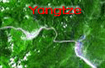
Yangtze
Yangtze
River is the longest river of Asia, about 6300 km (about 3937 mile) in length.
It rises in the Kunlun Mountains in the southwestern section of Qinghai
Province in China, and flows generally south through Sichuan Province into
Yunnan Province, where, in the vicinity of Huize, it bends sharply to the
northeast. Then, it flows generally northeast and east across central China
through Sichuan, Hubei, Anhui, and Jiangsu Provinces to its mouth in the
East China Sea, about 23 km (about 14 mi) north of Shanghai.
The
headwaters of the Yangtze are situated at an elevation of about 4900 m
(about 16,000 ft). In its descent to sea level, the river falls to an
altitude of 305 m (1000 ft) at Yibin, Sichuan Province, the head of navigation
for riverboats, and to 192 m (630 ft) at Chongqing. Between Chongqing
and Yichang (I-ch'ang), at an altitude of 40 m (130 ft) and a distance
of about 320 km (about 200 mi), it passes through the spectacular Yangtze
Gorges, which are noted for their natural beauty but are dangerous to
shipping. Yichang, 1600 km (1000 mi) from the sea, is the head of navigation
for river steamers; oceangoing vessels may navigatethe river to Hankou
(Hankow), a distance of almost 1000 km (almost 600 mi) from the sea. For
about 320 km (about 200 mi) inland from its mouth, the river is virtually
at sea level.
More
than 1,683,500 sq km (650,000 sq mi) of territory is drained by the Yangtze
and its branches. The principal tributaries are the Han, Yalong, Jialing,
Min, and Tuo He (T'o Ho), on the N and on the south, the Wu; at Zhenjiang,
the Grand Canal links the Yangtze to the Huang He (yellow River). During
periods of heavy rains, Lakes Dongting and Poyang receive some of the
overflow of the Yangtze. Despite these outlets, floods caused by the river
occasionally have caused great destruction of life and property. In the
20th century, devastating floods have occurred in 1905, 1980, and 1981.
With
its numerous tributaries and feeders, the Yangtze provides a great transportation
network through the heart of some of the most densely populated and economically
important areas in China. Among the principal cities on the Yangtze, in
addition to those cited in the foregoing, are Wuchang, Nanjing, Hanyang,
and Anqing (An-ch'ing). Jiangsu Province, largely a deltaic plain consisting
of silt deposited by the Yangtze (more than 170 million cu m/6 billion
cu ft annually), is one of the chief rice-growing areas of China.
Although
the entire river is known as the Yangtze River to foreigners, the Chinese
apply that designation only to the last 480 or 645 km (300 or 400 mi)
of its course, the portion traversing the region identified with the Yang
kingdom (flourished about 10th century BC). From Its upper reaches to
Yibin, the river is called the Jinsha River (Golden Sand) and various
other names are applied in the provinces it traverses. The official name
for the entire river is Chang Jiang ("Long River) or Yangtze River.
The
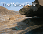
Yellow River
The
4,827 km-long Huanghe (yellow river) originates from Kunlun Mountains
and flows generally eastward across northern China to the Gulf of Bo Hai.
It is named for the vast quantities of yellow silt it carries to its delta.
The river often causes devastating floods on the plains of its lower course
due to elevated river bed.
Huanghe is also called the "mother river" of China as the Chinese
civilization is evolved in the region around the river. A 50-year construction
program, designed to control future flooding and harness the river for
increased irrigation and hydroelectric production, was initiated in 1955.
Passing
Cities :Anyang \ Jinan \Kaifeng\Lanzhou \Luoyang \Sanmenxia\ Wuzhong \Yanjin\
Zhengzhou
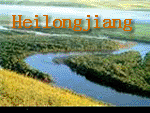
Heilong
Heilong
Jiang (Amur River) is the northernmost major stream of China. It forms
most of the northeastern boundary with Russia. It is a major fishing resource
in north China.
The
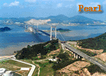
Pearl
The
Zhujiang (the Pearl) River is the largest river in south China, formed
but the confluence of three rivers---the Xijiang, Beijiang and Dongjaing.
Its name comes from pearl shells having been found in the section that
flows through the city of Guangzhou. The Xijiang, the trunk of the Zhujiang
(Pearl River), has its headwaters in the Nanpan River in the Wumeng Mountain
Area, Yunnan, and flows past Yunnan, Guizhou and Guangxi for 2,197 kilometers
before emptying into the South China Sea at Modaomen, Guangdong. Seventy-seven
percent of Zhujiang (Pearl River) flow comes from the Xijiang. Practically
all the rivers of the Beijinga and dongjaing systems are in Guangdong
Province. The Beijiang, starting in the southern part of Huanan and Jiangxi,
flows 468 kilometers. The Dongjiang has its source in southern Jiangxi
and a total length of 523 kilometers. The three rivers meet at the Zhujiang
River (Pearl River) Delta formed of the silt deposits at the river mount,
where they fan out and flow into the South China Sea through eight outlets,
mainly those at Humen, Hongqili, Modaomen and Yamen. The Zhujiang (Pearl
River) valley, which covers an area of 452,616 square kilometers, has
an annual precipitation of 1,500-2,000 mm. and is the region with the
largest rainfall. In length and catchment area, the Zhujiang (Pearl River)
ranks fourth among China's rivers, but its flow, eight times that of the
Huanghe, is second only to the Yangtze River and provides it with a power
potential of 33 million kilowatts. It is second also to the Yangtze River
in the volume of water transport, its trunk and branch rivers being navigable
for a total length of 12,000 kilometers. It is navigable by ships of 10,000-ton
class downriver form the Hangpu port near Guangzhou, by 1,000-tonners
up to Wuzhou and by small steamboats up to Nanning and Liuzhou. Farming
is well developed in the Zhujiang (Pearl River) basin. The Zhujiang River
(Pearl River) Delta has a network of rivers, fertile soil, abundant natural
resources and a sense population.
Zhujiang originates from Xijiang, one of the largest river system
in south China. Nicked named "Pearl River", Zhujiang is the
pearl of South China, fostering booming cities such as Guangzhou, Zhuhai,
Jiangmen in the entire delta region.
The river also witnessed the first episode of Opium War in 1840s, after
which Hong Kong, an island just outside Zhujiang's openning into South
China Sea, was turned to British colonial rule. Such a history ended on
July 1st, 1997.
Passing Cities:Guangzhou\Jiangmen\Xinhui \Zhuhai (1)
Lancang
Despite its size, Lancang offers a few places to spend the night. This is also a good place to sample traditional home cooking and hospitality. Those with time to kill can hire a bicycle to explore the surrounding area or simple wander around the town and relax beside the river. It is also possible to take a short boat trip along the river to the next town and back again.
One of the most interesting ways to reach Lancang is by taking a nine day tour of the Yangtze River, which terminates in Lancang. The trip takes visitors on a slow expedition through this region of China, with plenty of time to get off the river and explore.
Lancang is best reached by boat and it is connected to a number of towns and cities in this region such as Jinghong (20 hours). There is an international airport in Jinghong, which connects to most major cities in China as well as destinations such as Bangkok. Most visitors to Lancang pause here as part of a guided river tour of the region, which lasts for several days. It is also possible to reach Lancang by bus from some of the surrounding towns, although buses are far from regular.
Yarlung Zangbo
The Yarlung Zangbo River, an international water system, is located at the Tibet Autonomous Region and a river with the highest altitude in the world. The total length of the Yarlung Zangbo River in China is 2,057 kilometers, ranking the 5th longest river among the famous rivers of China. It has a drainage area of 240,480 square kilometers, and ranks the 6th largest river in China. Its annual runoff volume to foreign country is 140 billion m3, ranking the 3rd largest in China, just next to the Yangtze River and the Pearl River.
The Yarlung Zangbo River, which finds its source on the Gyaimanezong Glacier in Zongba County in the northern foothills of the Himalayas, belongs to the water system of the Indian Ocean. The Yarlung Zangbo River flows from west to east across the southern section of the Tibet Plateau. It first runs across Mailing, then turns to north and east before sharply flowing south toward and then flowing into India. After it flows into India, its name is changed to the Brahumaputra River, which later meets with the Ganges River before joining the Indian Ocean from the Bay of Bengal.
The total drop height of the Yarlung Zangbo River is over 5,400 meters in China, so it is the most precipitous river in China. The upper reaches are from the river source to Lizi, with a length of 268 kilometers. The river valley of this segment is broad and even, the river water is limpid and many lakes are located at this segment. Various grasses on the both sides of the valley are lush and they are colorful and sightly during the flowering season. Though sparsely populated, it is the Land of Peach Blossoms for wild animals. The wild yaks, Tibetan antelopes, bharals and other animals can be seen everywhere. In addition, there are some precious animals, such as the Tibetan wild donkeys, tableland foxes, snow leopards and marmots etc. Some birds of rare species for viewing and admiring also inhabit in the valley of the Maquan River.
The middle reaches of the Yarlung Zangbo River are from Lizi, through the Lazi, Rikaze, Qushui and Zedang, to Mailing County, with a length of 1,340 kilometers. The main distributaries of the Yarlung Zangbo River are flowing into the trunk river in the middle reaches. This segment can provide advantageous conditions for the plateau shipment due to its abundant water quantity, broad river surface and deep water. The rubber boats and wood boats can boat from the western Lazi to the eastern Zedang. This navigation segment is about 400 kilometers in length and it is the highest river segment of navigation in the world. With plenty of sunlight, good irrigation conditions and sparse population, it is the richest and most important agricultural area known as the Grain Barn of Tibet. The main crops include the highland barley, potato and wheat.
The lower reaches are from Paixiang of Mailing County to the Baxika, with a length of 496 kilometers. The vertical drop height from the Namjagabrwa Peak to the water surface of the Yarlung Zangbo River is 7,100 meters, so it is reputed as the deepest Grand Canyon (i.e. the Grand Canyon of the Yarlung Zangbo River) in the world. The river is narrow here, the reefs are everywhere on the riverbed, the river water is rapidly rushing and the waves are high. The spectacular downstream of the Yarlung Zangbo River has been the paradise of explorers all through the ages
Nujiang
Location: Situated in the northwest of Yunnan Province, Nujiang Lisu Autonomous Prefecture neighbors Lijiang City,Diqingand Dali prefectures in the east. It is also bordered by Tibet in the north and shares a boundary of nearly 450 kilometers (280 miles) with Burma in the west.
History: Yunnan, especially the western part, is an important cultural source of ancient China, and Nujiang Prefecture was the hometown of many primitive tribes. Along with many regions in Yunnan, Nujiang was brought under the administration of the central government in the Western Han Dynasty (206BC-24AD), and was later governed by Nanzhao (738-937) and Dali (937-1253) states during the Tang and Song dynasties. Nujiang Lisu Autonomous Region was established in 1954 and changed to a prefecture three years later.
Physical Features: Lying in the longitudinal valley area of Hengduan Mountains in western Yunnan, Nujiang is made up of lofty mountains and roaring rivers, with more than forty peaks in the prefecture over 4,000 (13,123) meters high. Its terrain generally slopes downward from north to south. Other than a small area of flat land on the fringe of Nujiang, Lancang and Dulong rivers, mountainous regions constitute the main part of Nujiang
Climate: Enjoying a plateau monsoon climate at low altitude, Nujiang is characterized by clear dry and wet seasons, great temperature difference between day and night and small temperature difference during the whole year. Due to the landform and altitude, it is colder in northern Nujiang and warmer in the south.
Local Highlights: Nujiang is the only autonomous prefecture for Lisu ethnic minority. Nu and Dulong are minority groups unique to Nujiang Region. Lanping Bai and Primi Autonomous County is the main community of Primi. People of ethnic minorities still maintain their traditional culture and customs
Liaohe**
Being one of the largest rivers in northern China, the Liaohe River is called the Mother River by people in Liaoning Province. Originated in Qilaotu Mountain in Heibei Province, it flows 1,394 kilometers through Hebei, Inner Mongolia, Jilin, and Liaoning provinces, and at last empties into the Bohai Sea, with a drainage area of 201,600 square kilometers.
The upper reaches of the river stretch 882 kilometers, running through loess hills; the middle reaches stretch 210 kilometers, to the Stone Buddha Temple; and the lower reaches have 302 kilometers.
The river abounds in precipitation rainfall especially in summer, which often causes serious floods in the lower reaches. Besides, the most challenging engineering aspect of taming the Liaohe River is the control of the exceptionally high sediment load that the river carries in its lower reaches, with 20.98 million tons of sediment on the average entering the river channel annually, only next to the Yellow River and the Haihe River.
In recent years, the water quality of Liaohe River is quite bad on the whole and the river system is heavily polluted. The major pollution indicators are ammonia nitrogen, total mercury, volatile phenols and permanganate index. After several years of treatment since 1993, the monitoring data showed some progress. In the eight local cities of the river valley, six sewage treatment plants with a total daily treatment capacity of 1.07 million tons were established. Industrial pollution sources of the river valley basically reached the emission standard.
Haihe
The Haihe, the largest water system in north china, is formed by five large rivers―the North Canal, the Yongding, the Daqing, the Ziya and the South Canal―and more than 300 tributaries these spread out like a palm-leaf fan over the vast areas in north China and converge near Tianjin to form the Haihe, which then flows east and empties into the Bohai Sea at Dagukou. This 69-kilometer trunk of the Haihe from Tianjin to Dagukou is like the handle of the fan, channeling the more than 300 tributaries into the sea. The Haihe basin covers Beijing, Tianjin, the greater part of Hebei, and parts of Shandong, Henan, Shanxi and Inner Mongolia. It has a catchment area of 265,000 square kilometers and 180 million mu of farmland. The Haihe has its source in the Weihe river and total length of 1,090 kilometers.
The rainy season is concentrated in a very short period in the Haihe valley. When heavy rains occur, the torrents of the numerous tributaries in the upper reaches rush into lwo-lying middle and lower reaches, where the river is narrow and there is only one outlet to the sea, causing it to burst onto the plain in treat floods. The city of Tianjin was inundated on more than 70 occasions in the 500 years or more before 1949. In a major flood in 1939, vast areas in the North China Plain were submerged, and the water in the streets in Tianjin were two meters deep, so that boats were the only means of transport for upwards of two months. In 1963, the Haihe basin was hit by a flood with out parallel in history. In eh following decade or more, comprehensive measures have been taken to bring the river under permanent control. More than 1,580 reservoirs and 4,3000 kilometers of dykes have been built, the river channels have been dredge, and 10 additioanl outlets to the sea have been opened, raising the flood-diversion capacity more than 10 times. Now the Haihe basin is basically free from the menace of floods.
Huaihe
The
Huaihe, an important river in central China, flows from west to east,
with the Huanghe in the north and Yangtze River in the south. Starting
in the Tongbai Mountains in Henan, it has its upper reaches in Henan,
its middle reaches in Anhui and its lower reaches in Jiangsu. Its trunk
is about 1,000 kilometers long and its catchment area about 185,700 square
kilometers. The Huaihe basin is mostly plain and has a cultivated area
of more than 200 million mu.
The Huaihe
had its outlet to the sea about eight centuries ago. In 1194, the Huanghe
breached its own dykes and merged with the downriver course of the Huaihe.
Before it reverted to its old course in mid-19th century, the Huanghe
had deposited large amounts of mud and silt in the lower reaches of the
Huaihe and sealed up the latter’s outlet to the sea. With the passage
of time, the waters of the Huaihe converged to form two large lakes, Hongze
and Gaoyou. In its high-water season the Huaihe flows through the Honze
and Gaoyou lakes and the Grand Canal into the Yangtze River near Yangzhou
before emptying into the sea. Because its lower reached its dykes and
caused 250 major floods in the five centuries or more before 1949. Since
the birth of the People’s Republic of China in 1949, many reservoirs and
flood-detention projects have been built in its upper and middle reaches,
new courses have been laid out in its lower reaches and its outlet to
the sea has been widened. In this way, the greater part of its water now
flows into the Yangtze River and the rest into the Huanghai Sea through
the new channels. Today, the Huaihe basin has an irrigated area of about
100 million mu, and the disaster-ridden, low yielding region is on its
way to prosperity.
Yili River
Yili Kazak autonomous prefecture (shortened as Yili prefecture) situates in the northwest border of People’s Republic of China, also in the northwestern part of Xinjiang Uighur autonomous region. It borders Russia and Mongolia in the northeast, and it connects Changji Hui Autonomous Prefecture and Bayinguoleng Mongol autonomous prefecture in the southeast. It faces Akesu area in the southwest, and it borders the Republic of Kazakhstan in the northwest.
The autonomous prefecture has an area of 350 thousand square kilometers and occupies one fifth of Xinjiang Uygur autonomous region. The borderline in Yili Kazak Autonomous Prefecture is as long as two thousand kilometers and it is three fifths of the borderline in Xinjiang. Along the borderline there are eight trading ports at national level.
The trading ports have already become the cultural and economic bridgehead between China and Central Asia, east Europe and Russia. “Three mountains, two valleys, and three basins” is the brief summary of the geography in Yili Kazak Autonomous Prefecture. The moun |
#
####China
Basics
###History
of China
###Provinces&
Cities
###Art
& Craft
###Population
###Mountains
###Rivers
###Lakes
###Seas&
Deserts
###Glacials
###Climamte
of China
###Vegetation
###Pedogeography
###Grassland
Islands
###Water
Resources

Related Books  China's Largest River-Changjiang China's Largest River-Changjiang
 Atlas of River Ice in China Atlas of River Ice in China
More...
 |